Current Projects
Gulf of Orosei BioMap
In Collaboration with the Phreatic Project
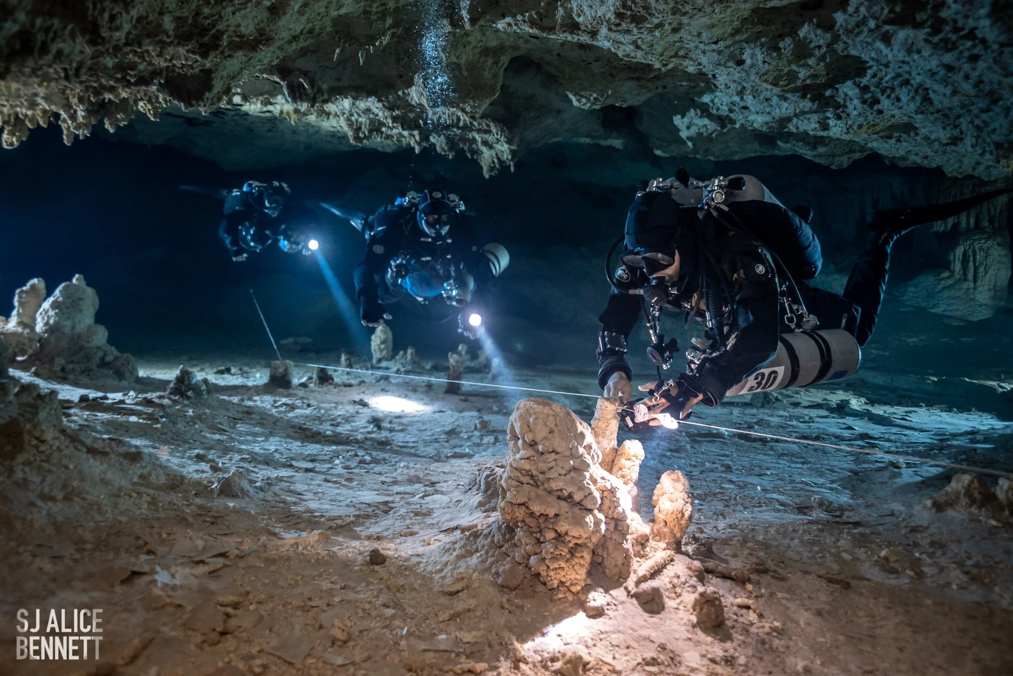
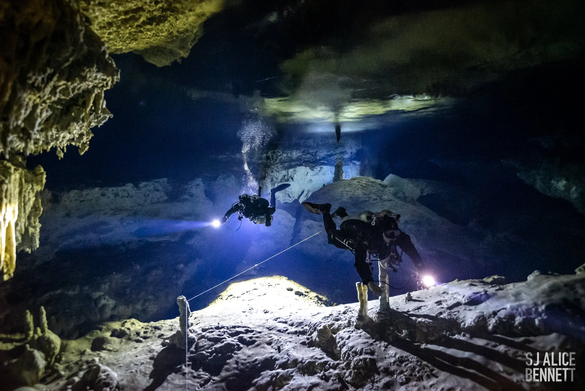
Subterranean environments are mostly unexplored. Vast unknown ecological information lies just below the terrestrial surface. The Gulf of Orosei coastline is characterized by hundreds of caverns and caves (both dry and flooded), with some of the longest anchialine underwater cave systems of Europe.
These springs are fresh water rivers with intrusion of saltwater from the sea. Multiple decorations and speleothems testify to the varying water levels during different ice ages and prove such environments were once dry; multiple branching passages, sumps and long shallow galleries make these caves one of the premiere cave diving destinations in Europe and a maze still to be discovered and explored.
Despite the fact that the Water Framework Directive (2000/60/ EC) and the Groundwater Directive (2006/118/EC) mention groundwater habitats as very important for biodiversity and human use, no data is available from most countries on underground water resources.
The Marine Genome Project team will be accompanied by a documentary film crew comprising of Jeremy Là Zelle and Aleksandr Rikhterman. The team will document the from start to finish the expedition. The short film will be used to help bring awareness to the importance these cave systems play in the health of the ocean.
-
Our project aims at closing this information and knowledge gap in the study area of the Gulf of Orosei, by providing scientific techniques to identify species living within the cave systems.
-
One of the tools our team will use is environmental DNA (eDNA). Allowing us to understand the ecology and distribution of species reliant on groundwater in the cave systems.
This non-invasive technique uses sediment and water samples to trace and identify species living in the cave system.
-
By using eDNA techniques we are able to understand and explore potential underground interconnectivity, provide information on the patterns of species diversity, and increase our knowledge of ecosystem fragility in underwater caves.
You Can Help Protect Ocean Ecosystems
Cenote BioMap
Subterranean environments are mostly unexplored. Vast unknown ecological information lies just below the terrestrial surface. The Yucatan and Tulum, Mexico area is characterized by thousands of caverns and caves (both dry and flooded), home to some of the longest cave systems in world.
These springs are fresh water rivers with intrusion of saltwater from the sea. Multiple decorations and speleothems testify to the varying water levels during different ice ages and prove such environments were once dry; multiple branching passages, long shallow galleries make these caves one of the premiere cave diving destinations in the world. Groundwater habitats such as the ones found in the region are very important for biodiversity and human use, no data is available from most countries on underground water resources.
-
Our project aims at closing this information and knowledge gap in the study area of the Tulum, Mexico area by providing scientific techniques to local diving team to identify species living within the cave systems.
-
One of the tools our team will use is environmental DNA (eDNA). Allowing us to understand the ecology and distribution of species reliant on groundwater in the cave systems.
This non-invasive technique uses sediment and water samples to trace and identify species living in the cave system.
-
By using eDNA techniques we are able to understand and explore potential underground interconnectivity, provide information on the patterns of species diversity, and increase our knowledge of ecosystem fragility in underwater caves.
Nixie Expeditions x Marine Genome Project
Expedition Buteng brings together a renowned international and Indonesian team of underwater cave explorers, cartographers, scientists, speleologists and photographers to work closely with the Indonesian government, the University of Gadjah Mada (UGM) and locals to conserve and protect the freshwater aquifer
The extensive science will be conducted in collaboration with the University of Gadjah Mada, led by Dr. Eko Haryono and a handpicked team of specialist scientists from UGM.
The cave divers and speleologists will become the hands and eyes of the scientists inside both the dry and the submerged caves, to help them study areas that have never been accessed before. Together, the teams will investigate and study the following, but not limited to:
eDNA
Climate changes
Microplastics in groundwater
Hydrology, and karst morphology
Cave biology and evolution
-
Expedition Buteng will be investigating one of the major freshwater reservoirs of the island of Pulau Muna, with the intention of creating unified and sustainable access to the groundwater. The direct result will be measurable by limiting plastic waste and increasing welfare of the local communities.
Currently, there’s no groundwater access provided by the government.
Villages across the island acquires water through various means. Some have costly access to local pump systems; others are buying water from privately owned aquifers. Many import bottled water via freight shipping.
Besides investigating the scientific aspects of the unique freshwater aquifer, the cave diving team will push to explore the actual size, to help understand how the resource can be sustainably sourced.
The water is nestling underground in a massive cave system, formed inside an ancient coral reef, making the exploration both stunning and challenging.
-
Pulau Muna is known as “The Island Of A Thousand Caves” in Bahasi.
Cave entrances are found all over the island, and several have evidence of human activities in the form of cave art dating back thousands of years.
During the expedition, a team of speleologists will explore and survey two large dry cave systems, prospecting for entrances into the aquifer.
There is currently only one known entrance down to the water. Finding more will extend the knowledge of the geography of the water and increase accessibility to the water.
Several of the team members of professional speleologists are also scientists, including an Archeologist and a Biologist. The dry cave team have explored dry caves all over Indonesia. Several are also cave divers, as this has been a needed skill on previous expeditions. Read more about the dry cave team HERE
Besides hoping to connect dry and wet caves, the dry cave team will also be collecting scientific data to support the long term goal of turning the area into a geopark.
Currently, the island has little tourism, but those who do travel to Pulau Muna, are mainly there to travel back in time by visiting the world famous cave art.
By establishing a geopark, geo-tourism can be nurtured and grown, creating a future with a more sustainable and environmentally friendly revenues for the communities.
-
The island of Pulau Muna is a fossilized prehistoric coral reef, and this fact is evident everywhere on land. Fossilized corals and crustaceans are now a part of every rock that is turned over.
The fossils are unique, and they could potentially create economic income by attracting moderate eco-tourism, both inside the dry caves and in the water-filled cave sections.
Given that similar areas are vulnerable to exploitation by the concrete industry, the local government is interested in more long-term, sustainable, and eco-friendly revenue streams for the communities.
During the expedition, the fossils will be documented, and with the expected proof of uniqueness, the authorities of Buton Tengah strive to protect the area by creating a National Geopark, with the long-term goal of applying for it to become a UNESCO Global Geopark.
-
Education, both inside and outside the borders of Indonesia, is a vital objective of the expedition to help manifest the unique nature, beauty, and importance of Indonesia’s underground aquifers.
To deepen global understanding of water conservation, outreach programs will be conducted during the expedition, targeting youth and university students through live broadcasts. The team will reach thousands of individuals on virtual field-trips through the platform“Exploring by the Seat of Your Pants”.
Additionally, the team, consisting of scientists, professional explorers, and visual storytellers, will deliver scientific and impactful articles across a wide range of industries. High-end photography and videography, both above and below the water, will be captured by world-renowned photographers to support the team’s efforts.
